
Nordova
Restricted: only its creator, the people they add and admins can edit this page.
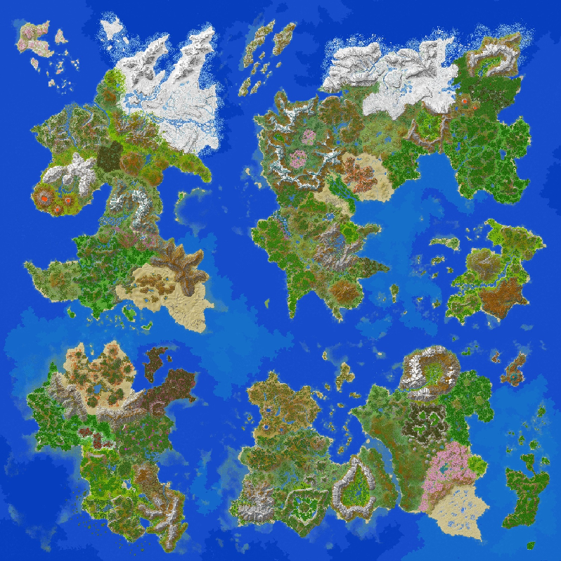
Nordova, formerly Continent 1, is the north-western continent of Pactoria's second iteration. As described by staff, it is clean, minimalist and grounded in realism. It is also the second-largest continent by landmass.
At a glance
- Location: the north-west of the world
- Size: the second-largest continent
- Magic: the weakest of any continent
- Regions: North, East, West and South, with 28 subareas
- Largest subarea: the Aureth Reach
- Ancient power: the Frosvaran Empire
Landmarks
- Berjavík, capital of the Frosvaran Empire
- The Ice Dungeon, in the Whitefang Peaks
- Dunskaert Fortress, on the Beringen Peninsula
- The Rikelig Mines, in the Nivafol Mountains
- The Khetem Pyramid, in the Oseryn Desert
- The Pillars of Heaven, in the Karst Desert
Introduction
Nordova's history is shrouded in mystery, with ruins and fortresses as the only proof of civilization there. It is also the continent with the weakest presence of magic, leaving Mother Nature herself to shape its landscapes and landmarks.
One of the most prominent ancient civilizations on the continent was the Frosvaran Empire. It ruled a third of Nordova with an iron fist for centuries, until it was toppled in the Great Frosvaran Crisis.
Yet civilization has not abandoned Nordova forever. As the march of civilization begins anew across this ancient land, will the new generations uncover the secrets of the past, or leave them buried and forge a future of their own?
Nordova North
Nordovar Isles
The Nordovar Isles are the only subarea of Nordova that has never been inhabited since the Great Renewal, largely because of their harsh and inhospitable climate. The isles were once part of the Whitefang Peaks before they broke away from the mainland. Nordovan locals knew of them, but the unforgiving, seemingly eternal winter made travelling there virtually impossible.
Akihana Archipelago
The Akihana Archipelago was unknown to Nordovan locals until about a century ago, when boats were reinvented and long-distance travel became possible again. The archipelago once lay beneath the sea and only emerged during the Great Renewal. The Akihanan Plateau, the tallest land on the largest island, is evidence of this.
Whitefang Peaks
The Whitefang Peaks are the highest mountains in Nordova and one of the coldest subareas on the continent. Their treacherous weather and extreme conditions make reaching the highest peaks a formidable challenge.
The Whitefang Peaks are also home to the Ice Dungeon.
Frosvaran Reach
The Frosvaran Reach is one of the coldest subareas in northern Nordova, best known for the frozen rivers that run across its two halves. The western half is mostly snowy plains, with an island in the middle of Frosvara's frozen lake. The eastern half is dominated by snowy slopes that border the Iceveil Highlands and the Whitefang Peaks.
The Reach was the heartland of the Frosvaran Empire, a vast ancient civilization famous for its many fortresses. Known together as the Northern Ice Spire Fortresses, these strongholds were scattered across the Frosvaran Reach, the Whitefang Peaks and the Iceveil Highlands. The most famous was Berjavík, the empire's capital.
Legend says the northern gods built the fortresses to shelter the local people from the bitter cold, and that Berjavík was among the first of them.
Stravelyn Drylands
The Stravelyn Drylands are a small, dry taiga in northern Nordova. The Whitefang Peaks catch the moist air and cast a rain shadow over the region, so only dry air reaches the Stravelyn Drylands.
Thalen Hill Land
The Thalen Hill Land, also known as the Thalen Larchland, is a hilly subarea in northern Nordova named after its vast larch forests. Its cold climate comes largely from its closeness to the Frosvaran Reach.
Cinderwood Mountains
The Cinderwood Mountains are a range that shields three major confluences. Two lie to the north-west and flow into the Frosvaran Reach; the third flows toward the Iceveil Highlands.
Like the Stravelyn Drylands, the Cinderwood Mountains are a dry taiga. The region is also known for its many bushes and dense undergrowth.
Nordova East
Iceveil Highlands
The Iceveil Highlands are the second-largest subarea in Nordova, after the Aureth Reach, and the largest in the north. The Iceveil River forms a natural border: its left bank counts as Nordova North and its right bank as Nordova East. The region was finally classed as Nordova East to settle a long dispute over who it belonged to.
Huge slopes rise on both sides of the Iceveil River, Nordova's longest river, which widens into a delta in the east before reaching the sea. The highlands are also known for the mysterious ice crystals scattered across them, which no one has ever been able to explain.
Cinderwood Lowlands
As the name suggests, the Cinderwood Lowlands lie within the Cinderwood region, bordering the Iceveil Highlands to the north and the coast to the south and east.
They are home to Cinderwood's signature tree, the Tundran blood-red tree. At the tip of the Beringen Peninsula stands Dunskaert Fortress, one of the region's best-known landmarks.
Cinderwood Basin
The Cinderwood Basin is a central subarea of Nordova known for its enormous confluences, much like those of the Cinderwood Mountains, which eventually flow into Inskamt Lake.
Its eastern half is mostly a large plateau, while the western half, especially along the coast, is lined with steep cliffs overlooking Cinderwood Bay.
Montaran Plains
The Montaran Plains stretch across Nordova's central "neck", a natural transition between the swamps and tundras of Elderwood and Cinderwood and the mountains of the Nordovan Divide.
Sereva Cays
The Sereva Cays are a group of tropical islands in Cinderwood Bay. They are the smallest subarea in Nordova by landmass.
Nordovan Divide
The Nordovan Divide is a mountain range along Nordova's "neck". As its name suggests, it separates the northern half of the continent (Nordova North, East and West) from Nordova South.
The range winds like a snake. A popular theory holds that Nordova was once two continents that collided and merged, and that the Divide is what remains of that ancient collision.
Nordova West
Emerald Corrie
The Emerald Corrie was formed by the remains of a continental glacier that once covered much of northern Nordova. It is believed that the three volcanoes to the south erupted beneath the ice, cracking and melting the glacier and giving rise to the Corrie.
It is also where the Frosvaran Empire suffered its first major defeat. In the legendary Battle of the Corrie, the local people drove the empire's forces back, a turning point in Frosvaran history.
Ruvira Shrublands
The Ruvira Shrublands, also known as the Ruvira Valley, lie between the Cinderwood Mountains and the eastern slopes of the Emerald Corrie. They are covered in bushes and shrubs, and are one of the flattest subareas on the continent.
Sylrath Steps
The Sylrath Steps are a series of raised lands covered in taiga forest. During the short summer the snow melts, feeding the soil and waterways so that colourful flowers bloom across the region.
Elderwood
Elderwood is an ancient swamp in the centre of Nordova. It was once home to large communities of witches, although most have been driven out in recent times.
Nivafol Mountains
The Nivafol Mountains separate the Sylrath Steps from the Boreal Lowlands, and are home to the Rikelig Mines.
In the Frosvaran language, "Rikelig" means "head". The range was said to look like a human figure, with the mines where the head would be.
Boreal Lowlands
The Boreal Lowlands lie between the Nivafol Mountains and the Ignisara Wastes. They are home to blooming pines, a biome found nowhere else in Nordova, believed to come from the region's closeness to both a mountain range and an active volcanic area.
Ignisara Wastes
The Ignisara Wastes are a volcanic ridge famous for their three active volcanoes, and one of the most geologically active places in Nordova.
Nordova South
Lacora Veil
Also known as the Great Southern Delta, the Lacora Veil is the vast delta where the Lacora River meets the sea. It holds part of the Verdantian Forest, a huge birch forest that stretches across the Lacora Veil and the Verdantian Slopes.
Verdantian Slopes
The Verdantian Slopes lie between the Lacora Veil to the north and the vast Aureth Reach to the south. They hold the southern part of the Verdantian Forest and, as the name suggests, are full of slopes and highlands.
Wylder Meadows
The Wylder Meadows are a vast meadow at the south-western tip of Nordova, covered in flowers of every size and kind. They border only the Aureth Reach, to the east.
After the failed Frosvaran Southern Expedition, rumours spread that some of its travellers had survived and reached "the most beautiful meadow". Many believe this meant the Wylder Meadows.
Aureth Reach
The Aureth Reach is the largest subarea in Nordova, covering about a third of the continent's southern half. Besides its vast rainforest, it is dotted with slopes and lakes.
It was long a deadly crossing between Nordova's northern and southern halves: its size and dense rainforest made it easy to get lost, and its many highly poisonous animals made survival even harder.
Isles of Silvaris
The Isles of Silvaris are Nordova's southernmost subarea, just beyond the border between the Aureth Reach and the Oseryn Desert. Like the Sereva Cays, they have a tropical climate and many exotic trees.
Arden Mountains
The Arden Mountains are a large range surrounded by the Aureth Reach and the Karst Desert, and the source of three major local rivers.
Oseryn Desert
The Oseryn Desert is home to the Khetem Pyramid. It is dotted with small oases, with larger patches of savanna around its centre.
A rare, exotic cactus also grows across the desert, though it is seldom seen.
Karst Desert
The Karst Desert is the south-easternmost subarea of Nordova and holds the continent's southernmost point. It is best known for the mysterious Pillars of Heaven, rock formations found nowhere else.
Some believe the Pillars were once under the sea, but their true origin remains a mystery.
Supplementary lore
The Frosvaran Empire
The Frosvaran Empire was a large empire that existed from the resurfacing of humanity until roughly 500 years ago, although the exact date of its collapse is still debated.
At the time, many tribes were scattered across Nordova, constantly fighting one another, until a prodigy rose from the Frosvaran tribe. His name was Gondleger, one of the very few known figures of the empire, and he became its founder and first emperor.
Known even among locals as the "Cunning Emperor" for the psychological tactics he used to unite tribes, gather strong men and expand, Gondleger had conquered much of northern Nordova by the time he died. Much of this was credited to the Montara Route, which linked the northern subareas, and to a revolutionary military system that could keep Frosvaran soldiers supplied with food and weapons almost anywhere, at any time.
After Gondleger's death came the empire's first crisis, the Frosvaran Succession Crisis. The order of events is unclear, but it is generally agreed that his brother Janus succeeded him and hunted down the siblings who competed for the throne. Whether any of them survived is still a mystery.
Under Janus the empire turned to far more aggressive expansion: slaughtering occupied villages, destabilising other tribes from within, and investing in military rather than farming technology. This marked the start of Frosvara's technological boom.
Among Janus's ambitions was a rumoured icy temple in the Whitefang Peaks, the home of a yeti of overwhelming strength said to rival the might of the empire itself. He sent more than a thousand soldiers to conquer it, and the army was crushed by a masked yeti and its minions. Humiliated, Janus tried to erase the defeat from the records, but historians uncovered it anyway.
Decades later came the second crisis, the Battle of the Corrie, which lasted a thousand days and a thousand nights. Heavy Frosvaran losses, shortages from the cost of the war and unrest at home marked the beginning of the empire's downfall, along with its first major defeat and its retreat from the Emerald Corrie.
From there, historians cannot say exactly when the empire fell. Its collapse stretched over decades, and the burning of the Cinderwood Library made recovering its history even harder.
The Frosvaran Southern Expedition
Some time before its fall, the Frosvaran Empire sent an expedition south to find fertile, farmable land for a new settlement. The decision was driven largely by rumours from merchants who had travelled through southern Nordova.
At first the expedition went smoothly, until it reached a seemingly impassable obstacle: the Nordovan Divide. Half of the travellers turned back, spreading the belief that the Divide marked the edge of the known world. The other half pressed on south.
Crossing the Divide proved far harder than expected, and it cost the lives of most, if not all, of those who tried. Their fate remains unknown, as none of them ever returned to the empire.
Months later, a rumour spread through the empire that several members of the expedition had survived and reached "the most beautiful meadow". Many believe this was the Wylder Meadows, though it has never been proven.
Imported from https://wiki-beta.pactoria.net/w/index.php?title=Nordova (MediaWiki). Check the source's licence.